Chengdu Wanggan Technology Co., Ltd.

Chengdu Wanggan Technology Co., Ltd.

Manufacturer from China
Active Member
5 Years
Home / Products / Handheld GPS Surveying Units /

Color Display Handheld GPS Surveying Units , Slope GPS Land Measuring Instrument

Contact Now
Chengdu Wanggan Technology Co., Ltd.
City:chengdu
Country/Region:china
Contact Person:admin
Contact Now

Color Display Handheld GPS Surveying Units , Slope GPS Land Measuring Instrument

Ask Latest Price
Video Channel
Brand Name :WangGan
Model Number :S4
Place of Origin :China
MOQ :2
Price :$78-$85
Payment Terms :T/T, Western Union, MoneyGram
Supply Ability :10000 sets/month
Delivery Time :10 working days
Packaging Details :19*15*9cm 0.4kg
Machine Type :Handheld GPS Surveying Units
Use range :Farmland, Pond Or Lake, Outdoor Survey etc
Satellite signals :GPS GLONASS SBAS BeiDou
Battery Type :Lithium Battery
Application :Flat, Slope, Mountain Distance Area Measurement
Mountain measurement :Support
Slope measurement :Support
Feature :Handheld GPS Survey Equipment
more
Contact Now

Add to Cart

Find Similar Videos
View Product Description

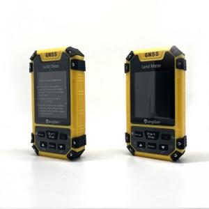
GPS Land Length Area Measuring Color Display Handheld GPS Surveying Units

The Unit Price Of Handheld GPS Surveying Units:

① On the home page of boot,press the 【Settings】button to enter the settings interface;

② Press the▲▼button move to“unit setting”;Press the【Enter】button to enter;

③ Press the【Enter】button to choose the unit price;

④ Press ▲▼ button to adjust the value of number;

⑤ After finishing setting,press the "Stop" button to exit.

Note: After the setting of unit price, the amount can be viewed in the data display of the measurement interface, or in the measurement record details interface.

Conversion Ratio Of Mu/Acre/Large Mu/Hectare/ To Square Of Handheld GPS Surveying Units:

① On the home page of boot,press the 【Settings】button to enter the settings interface;

② Press the▲▼button move to“unit setting”;Press the【Enter】button to enter;

③ Press the【Enter】button to the scale item;

④ Press ▲▼ button to adjust the value of number;

⑤ After finishing setting,press the "Stop" button to exit.

Note: When the scale is set, the square corresponds to the scale when it is measured.

Color Display Handheld GPS Surveying Units , Slope GPS Land Measuring Instrument

Color Display Handheld GPS Surveying Units , Slope GPS Land Measuring Instrument

Color Display Handheld GPS Surveying Units , Slope GPS Land Measuring Instrument

Color Display Handheld GPS Surveying Units , Slope GPS Land Measuring Instrument

Color Display Handheld GPS Surveying Units , Slope GPS Land Measuring Instrument

Color Display Handheld GPS Surveying Units , Slope GPS Land Measuring Instrument

Color Display Handheld GPS Surveying Units , Slope GPS Land Measuring Instrument

Color Display Handheld GPS Surveying Units , Slope GPS Land Measuring Instrument

Color Display Handheld GPS Surveying Units , Slope GPS Land Measuring Instrument

Color Display Handheld GPS Surveying Units , Slope GPS Land Measuring Instrument

Color Display Handheld GPS Surveying Units , Slope GPS Land Measuring Instrument

Color Display Handheld GPS Surveying Units , Slope GPS Land Measuring Instrument

Color Display Handheld GPS Surveying Units , Slope GPS Land Measuring Instrument

Color Display Handheld GPS Surveying Units , Slope GPS Land Measuring Instrument

Color Display Handheld GPS Surveying Units , Slope GPS Land Measuring Instrument

Color Display Handheld GPS Surveying Units , Slope GPS Land Measuring Instrument

Functions S4
Positioning accuracy 2.5m
Initial barometric calibration
Normal area measurement
Mountain area measurement
Intell. Slope measurement
Fixed point measurement
Fixed width area measurement
Normal distance measurement
Manual distance measurement
Altitude display
Altitude measurement
Track display
Mu setting
Unit setting
Time display
Data statistics
Historical record
Lighting /Currency detection
Dry battery
lithium battery
Data storage 200
Voice broadcast
Data export
Inquiry Cart 0